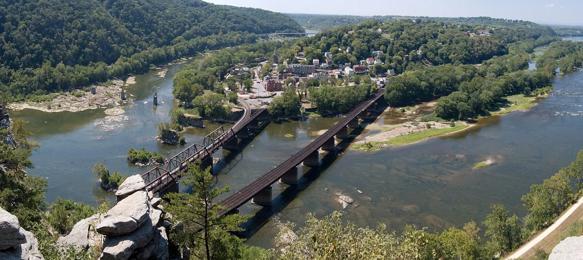
Harpers Ferry is spread across three levels: the river and Lower Town at the bottom, the ridge-top streets of Harpers Ferry and Bolivar above, and the Visitor Center and its big parking lot up by US 340. Knowing where each piece sits saves a lot of walking uphill. This guide lists every key place with its address or access point and, where an official or encyclopedic source publishes them, its GPS coordinates.
Know before you go
| Official maps | Free PDF trail maps — NPS maps page; printed copies at the Visitor Center |
| Start here | Visitor Center, 171 Shoreline Drive, Harpers Ferry, WV 25425 |
| Visitor Center GPS | 39.31667, -77.75639 — NPS directions |
| To Lower Town | Shuttle every 10–15 min from 9am, or a 1.6-mile trail |
| Lower Town maps | At A Place in Time (Information Center unstaffed as of Nov 2026) |
| Phone signal | Unreliable; download the NPS app's offline content first |
| Footbridge | Closed (as of Nov 2026) — status |
Where can you get an official Harpers Ferry map?
The National Park Service publishes free, printable trail maps on its Harpers Ferry maps page, and the Visitor Center hands out printed copies. As of November 2026 the Lower Town Information Center is not staffed, so in Lower Town pick up maps at the A Place in Time exhibit space.
| NPS map (PDF) | Covers |
|---|---|
| Bolivar Heights and Schoolhouse Ridge North | 1862 battlefield trails on the ridge west of town |
| Camp Hill and Virginius Island | The A.T. through town, Camp Hill and the Shenandoah islands |
| Visitor Center to Lower Town | The 1.6-mile walking route down to town |
| Murphy-Chambers Farm | Fields and earthworks near the Visitor Center |
| Schoolhouse Ridge South | Southern battlefield trails (southern loop closed for sinkholes as of Nov 2026) |
| Maryland Heights | Overlook Cliff and Stone Fort trails |
| Loudoun Heights | The Loudoun Heights trail on the Virginia side |
The NPS also offers its free app with a map of trails, overlooks and exhibits. The park warns that cell reception is unreliable, so download the offline content before you arrive.
Where are the parking lots?
The Visitor Center lot is the main one; Lower Town has two small NPS lots plus town paid parking. The park entrance fee covers parking in NPS lots.
| Lot | Spaces | Where | GPS |
|---|---|---|---|
| Visitor Center | About 1,000 (35 oversize, 24 accessible) | 171 Shoreline Drive, at the US 340 stoplight | 39.31667, -77.75639 (NPS) |
| Train Station lot | 81 | Lower Town, by the station on Potomac Street; no shuttle stop | Not published |
| River Access lot | 36 | US 340 at Shenandoah Street | Not published |
| Bolivar Heights lot | 8 | Whitman Avenue | Not published |
| ATC visitor lot | Small; 2-hour limit | Behind 799 Washington Street, entered from Storer College Place | Not published |
| Town paid zones | Not published | ParkMobile zones 7510, 7515 and 7520 | — |
| Maryland Heights (Sandy Hook Road) | Closed | Permanently closed in 2022 | — |
Spaces and rules come from the NPS parking page and the ATC. Fees, shuttle hours and overnight permits are in parking, fees and shuttle.
Navigate to the address, not the town
The NPS warns that many navigation apps send drivers into town, to Lower Town or to park headquarters instead of the Visitor Center. Enter "171 Shoreline Drive, Harpers Ferry, WV 25425" or the GPS point above.
Where are the main sights?
Most of the famous sights sit within a few blocks of each other in Lower Town, with St. Peter's, Jefferson Rock and the Storer College campus up the hill above it. Coordinates below come from Wikipedia or Wikidata entries for each place; we list none we could not source.
| Place | What it is | GPS (lat, lng) |
|---|---|---|
| John Brown's Fort | The armory engine house where John Brown's 1859 raid ended; open | 39.32345, -77.72989 |
| The Point | Where the Shenandoah meets the Potomac; views of three states | Not published; past the end of Shenandoah Street, beyond the railroad trestle |
| Harpers Ferry station | Amtrak and weekday MARC stop on Potomac Street; restrooms | 39.32444, -77.73111 |
| St. Peter's Roman Catholic Church | Church consecrated in 1833 (rebuilt 1896) above Lower Town, up the High Street steps | 39.32273, -77.73130 |
| Jefferson Rock | Rock outcrop on the A.T. where Jefferson admired the view in 1783 | 39.32261, -77.73328 |
| Storer College campus (Camp Hill) | Former college for African Americans, 1867–1955 | 39.32379, -77.73541 |
| Virginius Island | Shenandoah island trail with wayside exhibits | 39.32149, -77.73916 |
| ATC Harpers Ferry Visitor Center | Appalachian Trail Conservancy center, 799 Washington Street | Not published |
| Bolivar Heights | 1862 battlefield overlook with a replica cannon | 39.32806, -77.75806 |
Where are the trailheads?
Most trails start in or near Lower Town or at the Visitor Center. As of November 2026, the trails across the Potomac can be reached only by the Lock 34 shuttle.
| Trail | Where it starts | Notes |
|---|---|---|
| Visitor Center to Lower Town | Visitor Center | 1.6 mi one way, 150 ft downhill (NPS) |
| Murphy-Chambers Farm | Reached from the Visitor Center (NPS) | 1–3 mi |
| Virginius Island and Hall's Islands | Lower Town (see the NPS Camp Hill and Virginius Island map) | Up to 2 mi, easy |
| Camp Hill and the A.T. | High Street steps in Lower Town | Up to 1.8 mi; passes Jefferson Rock |
| Bolivar Heights / Schoolhouse Ridge North | Bolivar Heights lot, Whitman Avenue; Schoolhouse Ridge North has its own gravel lot | 0.3–2.4 mi / 1.7 mi |
| Loudoun Heights | From Lower Town on the A.T. across the Shenandoah (US 340 bridge) | Up to 7.5 mi; guide |
| Maryland Heights | Harpers Ferry Road, Maryland, 0.3 mi upstream of the footbridge along the towpath | Footbridge closed: use the Lock 34 shuttle; guide |
For distances, climbs and difficulty on every trail, see the Harpers Ferry hiking guide.
Where are the footbridge, the towpath and Lock 34?
The footbridge crosses the Potomac on the B&O railroad bridge from The Point to the C&O Canal towpath in Maryland. As of November 2026 it is closed, and a limited NPS shuttle runs from the Visitor Center to Lock 34 instead.
| Place | What it is | GPS (lat, lng) |
|---|---|---|
| Footbridge (B&O Railroad Potomac River Crossing) | Pedestrian walkway beside the railroad tracks; closed as of Nov 2026 | 39.32417, -77.72861 |
| C&O Canal Lock 33 | Towpath mile 60.7, across from Harpers Ferry | 39.32500, -77.72694 |
| C&O Canal Lock 34 (Goodheart's Lock) | Towpath mile 61.6; drop-off for the footbridge-closure shuttle, 0.9 mi upstream of the footbridge | 39.33306, -77.73889 |
| Maryland Heights trailhead | On Harpers Ferry Road, 0.3 mi upstream of the footbridge | Not published |
Lock coordinates are from Wikipedia's table of C&O Canal locks. The shuttle runs from 9:00am (first bus from the Visitor Center) to 5:30pm (last bus from Lock 34), with limited seats and no pets. Full details: footbridge closure status and detours.
Where are the restrooms?
The NPS lists these public restrooms in the park:
- Visitor Center: next to the building, with accessible stalls.
- Lower Town: a single-user, wheelchair-accessible restroom next to the bookshop.
- Train station: restrooms with accessible stalls.
- Schoolhouse Ridge North and South: wheelchair-accessible vault toilets (gravel parking).
- ATC Visitor Center: a restroom for visitors during opening hours.
There are no restrooms or drinking water on the Maryland Heights trail, and there are no trash cans anywhere in the park, so carry out what you bring.
How do you get between the main areas?
Use the shuttle between the Visitor Center and Lower Town, and walk within Lower Town and up the steps to the hilltop.
- Visitor Center to Lower Town: shuttle every 10–15 minutes, 9am to 5:30pm in standard time (7pm in daylight saving time), or the 1.6-mile trail. Pets can't ride.
- Lower Town to Jefferson Rock and Storer College: on foot, up the stone steps on High Street past St. Peter's.
- Lower Town to the ATC Visitor Center: uphill on foot through town, or drive to its 2-hour lot.
- Bolivar Heights: drive to the 8-space lot on Whitman Avenue.
- To Maryland: Lock 34 shuttle only while the footbridge is closed.
With kids, a stroller or a dog, see Harpers Ferry with dogs and kids. For a timed day built around these places, see the Harpers Ferry itinerary, and for the bigger picture, plan your visit.