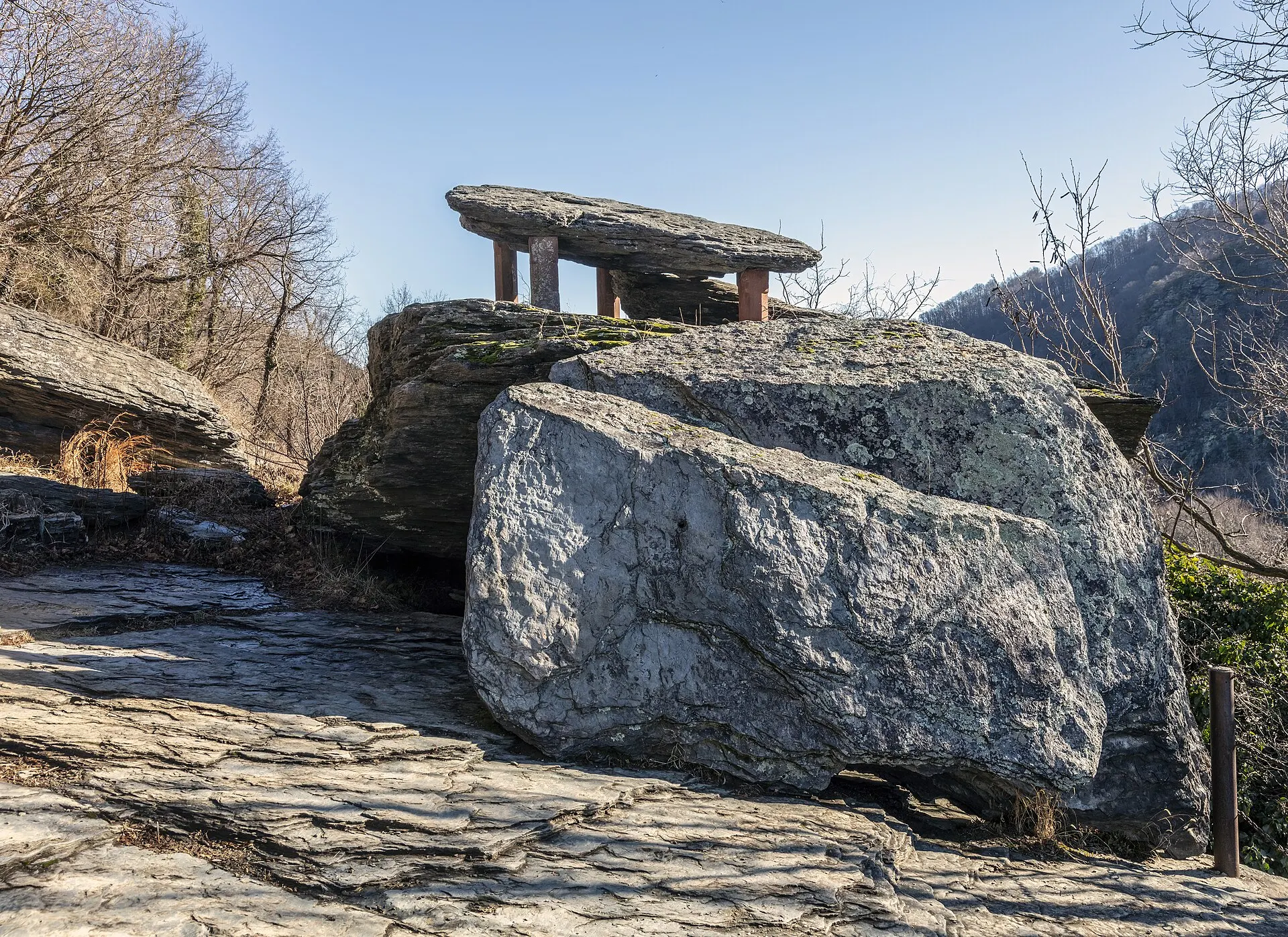
Jefferson Rock is the most famous viewpoint you can walk to from Lower Town Harpers Ferry, West Virginia, and it makes the natural high point of a self-guided walking tour. This guide strings it together with The Point, John Brown's Fort, the Shenandoah Street museums, St. Peter's Church, Harper Cemetery, the old Storer College campus and Virginius Island, in an order that works on foot from the shuttle stop. It's part of our things to do in Harpers Ferry guide.
Know before you go
| Start | Lower Town shuttle stop on Shenandoah Street. Park at the Visitor Center, 171 Shoreline Dr — parking & shuttle guide |
| Fee | Park entrance fee applies: $20 per vehicle or $10 per person 16+, valid 3 days, no cash — NPS |
| Jefferson Rock climb | The NPS counts 62 historic stone steps up from High Street, then a dirt path |
| Camp Hill loop | Up to 1.8 mi round trip and up to 216 ft of climbing; 2–3 mi with side trails — NPS |
| Time | Allow half a day for the full route with museum stops |
| Museums | Daily 9am–5pm. As of November 2026, four are temporarily closed — NPS conditions |
| Accessibility | Jefferson Rock and the stone steps are not accessible; The Point has a loose gravel path |
| Rules | No climbing on Jefferson Rock. No drones. Carry out your trash |
Where is Jefferson Rock, and why is it famous?
Jefferson Rock is a stack of large Harpers shale slabs on the Appalachian Trail, on the hillside between Lower Town and Camp Hill, overlooking the Shenandoah River just before it meets the Potomac. It is famous because Thomas Jefferson stood there on October 25, 1783, and later wrote one of the best-known descriptions of an American landscape about the view.
In Notes on the State of Virginia (Query IV), Jefferson wrote:
"The passage of the Patowmac through the Blue ridge is perhaps one of the most stupendous scenes in nature. You stand on a very high point of land. On your right comes up the Shenandoah, having ranged along the foot of the mountain an hundred miles to seek a vent. On your left approaches the Patowmac, in quest of a passage also. In the moment of their junction they rush together against the mountain, rend it asunder, and pass off to the sea." … "This scene is worth a voyage across the Atlantic."
The spelling is Jefferson's own from the 1787 London edition. Jefferson Rock was listed on the National Register of Historic Places in 1966 as a contributing property of the national park (Wikidata).
Why is Jefferson Rock propped up on pillars?
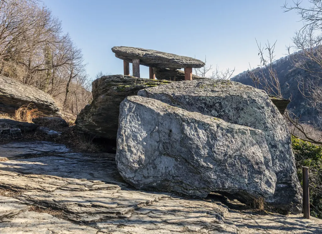
The top slab of Jefferson Rock used to sit on a natural stone base so narrow that, according to the NPS, someone could sway the rock back and forth with a gentle push. Weathering and what the park calls the "devastations of tourists and curiosity-hunters" wore that base down to "very unsafe dimensions." Sometime between 1855 and 1860, four stone pillars were set under the corners of the top slab to hold it in place, and they are still there.
The rock is still unstable. Walking on, climbing or crossing Jefferson Rock or the base rock under it is prohibited under federal park rules (36 CFR 2.1(a)(5)). The view is just as good from the path beside it.
What's the best walking route through Lower Town to Jefferson Rock?
Start at the Lower Town shuttle stop, see the riverside sights first while your legs are fresh, then climb. This route follows the NPS directions for The Point and Jefferson Rock and the NPS Camp Hill and Appalachian Trail loop.
- The Point. Walk along Shenandoah Street toward the buildings, turn right at the end of the street, pass John Brown's Fort and follow the gravel path up a slight incline until you see the rivers.
- John Brown's Fort. Step back down to the brick engine house you just passed. It is open as of November 2026.
- Shenandoah Street museums. Work back up Shenandoah Street through the open NPS exhibits (list below).
- The stone steps. Turn onto High Street. The steps start between the African American History Museum and the Civil War Museum buildings; the NPS counts 62 of them.
- St. Peter's Roman Catholic Church. The steps bring you up beside the church. Walk past it to the next set of steps.
- St. John's Episcopal Church ruins. Follow the path past the roofless stone ruins.
- Jefferson Rock. The rock is on the right of the white-blazed Appalachian Trail along the cliff.
- Harper Cemetery and Lockwood House. Just above Jefferson Rock, take the right fork. The ATC puts the cemetery about 0.1 mile from the rock.
- Storer College. Rejoin the A.T.; at a junction about a quarter mile along, the blue-blazed trail climbs stone steps to the former campus and its long brick walk.
- Virginius Island. Head back to that junction and take the Cliff Trail, which the NPS recommends: it drops steeply to Shenandoah Street opposite the pulp mill ruins. Cross the street and follow the Virginius Island trails about 0.5 mile back to Lower Town.
If you only want Jefferson Rock, do stops 4 to 7 and come back down the same steps. The NPS lists the Camp Hill loop at up to 1.8 miles round trip with up to 216 feet of climbing, or 2 to 3 miles and 1 to 2 hours with the side trails.
What can you see at The Point?
The Point is where the Shenandoah flows into the Potomac at the tip of Lower Town. The NPS says that from here you look into three states, Maryland, Virginia and West Virginia, as well as the confluence and the water gap in the Blue Ridge. The Appalachian Trail passes here on its way to the Potomac footbridge.
Look for the stone piers standing in the Potomac. They belonged to the Bollman bridge, completed by 1870, which carried the B&O mainline until 1894 and was destroyed for good in the record flood of 1936. Across the river, the faded painted sign on the Maryland Heights cliffs is a 1906 advertisement.
Footbridge closed
The Goodloe Byron Memorial Footbridge from The Point to Maryland is closed as of November 2026, with no reopening date. See our footbridge closure update.
What is John Brown's Fort?
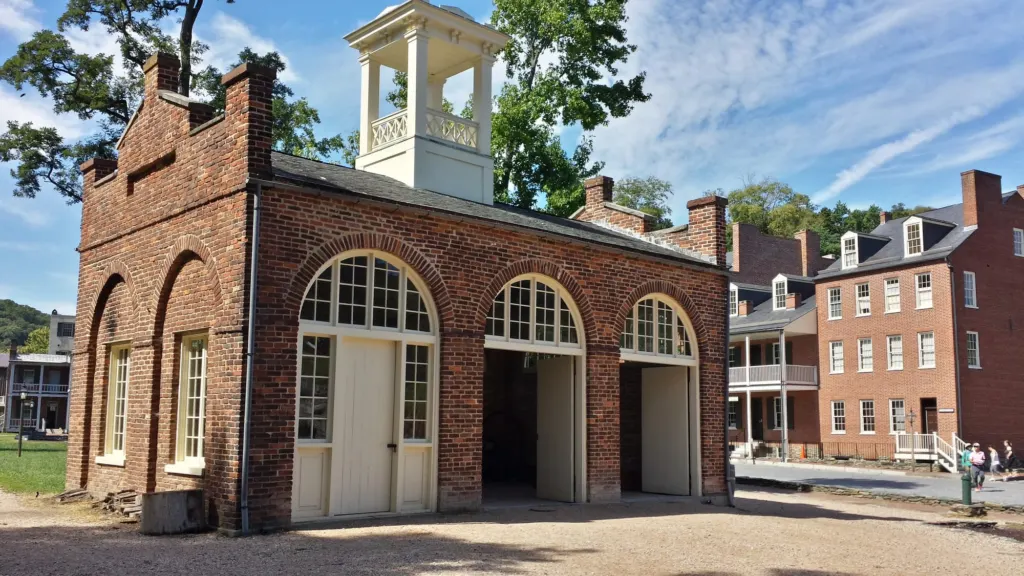
John Brown's Fort is the armory's brick fire engine and guard house, where John Brown and his remaining raiders made their last stand until U.S. Marines stormed it at dawn on October 18, 1859. It has been moved four times, including a trip to Chicago for the World's Columbian Exposition, and has stood at its present Lower Town site since 1968, about 150 feet from its original spot. It is open as of November 2026. Our John Brown's raid guide has the full story.
Which Lower Town museums are open right now?
As of November 2026, most Lower Town exhibits are open daily from 9am to 5pm, but four are temporarily closed. The Lower Town Information Center isn't staffed; pick up maps at the A Place in Time exhibit instead. Check the NPS conditions page on the day you go.
| Open (NPS, November 2026) | Temporarily closed |
|---|---|
| John Brown's Fort; John Brown Museum; Allies for Freedom | Master Armorer's Quarters |
| A Place in Time; Industry Museum; Reading an Old Building (archeology) | Black Voices / African American History |
| Boarding House; Dry Goods Store; Confectionery | Civil War Museum |
| Philip Frankel & Co. / Ready-Made Clothing; A. Burton Watch Repair / Burton Jewelry Store | Harper House |
| Provost Marshal's Office; White Hall Tavern; 1862 Battle of Harpers Ferry | |
| Meriwether Lewis at Harpers Ferry; Storer College & the Niagara Movement |
Harper House, finished in 1782, is the oldest surviving structure in Lower Town, so it's worth a look from outside even while its exhibits are closed.
What is St. Peter's Church in Harpers Ferry?
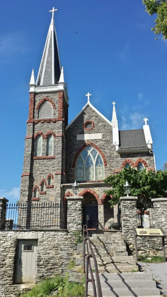
St. Peter's Roman Catholic Church is the spired stone church halfway up the climb to Jefferson Rock. It was completed in 1833, soon after Irish laborers arrived to build the C&O Canal and the B&O Railroad, and remodeled to its present look in 1896. The NPS says Father Costello flew the British Union Jack during the Civil War to signal neutrality, and the church came through the war relatively unharmed. It is still an active parish with Sunday Mass, so be respectful of services.
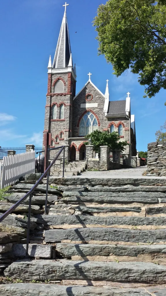
Just past it, the ruins of St. John's Episcopal Church stand on the hillside. The ATC notes the church was destroyed by shelling during the Civil War.
What is Harper Cemetery?
Harper Cemetery is the 4-acre burial ground that town founder Robert Harper set aside on Camp Hill; Harper himself died in 1782 and is buried there. The NPS points out the grave markers of descendants of his niece Sarah Wager and of Irish and German immigrants who settled here in the 1830s. Next to it stands the Lockwood House, where Storer College began.
What was Storer College?
Storer College was founded on Camp Hill on October 2, 1867, by Freewill Baptists to educate formerly enslaved people, starting as a normal school in the Lockwood House. It closed in 1955. In 1881 Frederick Douglass gave a speech on John Brown there, and in August 1906 W.E.B. Du Bois led the Niagara Movement's first public meeting in the U.S. on the campus, with members walking barefoot to John Brown's Fort at dawn. The park preserves the old campus, which is also home to the NPS Mather Training Center.
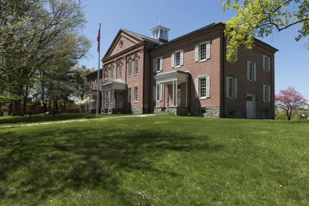
From the campus, the blue-blazed trail continues to the Appalachian Trail Conservancy Visitor Center at 799 Washington Street, the A.T.'s "psychological halfway point." For more, see our Storer College history.
What is Virginius Island?
Virginius Island is a former industrial island of about 12 acres on the Shenandoah River, created when the Patowmack Company cut the Shenandoah Canal in 1806 to 1807. It once held cotton and flour mills, a sawmill, an iron foundry, a rifle factory and worker housing. Floods ruined it: the 1870 flood killed 42 people on the island, the cotton mill was abandoned after the 1889 flood, and the 1936 flood ended settlement. Today the NPS keeps it as an archeological preserve with wayside exhibits; only the cotton mill's iron drive shafts remain of that building.
The Virginius Island and Hall's Island trail is the easiest walk on this route: up to 2 miles round trip, about 45 feet of climbing, 15 minutes to an hour, per the NPS.
How hard is the walk, and is it accessible?
The Lower Town part of the walk is short and mostly level, but the climb to Jefferson Rock is steep stone steps and a dirt path, and the NPS says Jefferson Rock is not accessible to people with physical limitations. The NPS rates the Camp Hill loop moderate.
For visitors using wheelchairs or other mobility devices, the NPS notes:
- Shuttle: Newer buses kneel and have a 30-inch ramp and two wheelchair spots.
- The Point: A loose gravel path with slopes up to 11.5 percent runs from Shenandoah Street.
- Sidewalks: Brick and natural stone, uneven in places, with few curb cuts.
- Step-free entrances: Meriwether Lewis at Harpers Ferry, the Niagara Movement exhibit and the bookshop, among others; A Place in Time, the Industry Museum and the John Brown Museum have step-free secondary entrances.
- Wheelchairs to borrow: Four, free, first come first served, at the Visitor Center.
The Appalachian Trail is always open, but other park trails are open during daylight only, and the parking lots close 30 minutes after sunset. As of November 2026 the last shuttle back to the Visitor Center leaves at 5:30pm, so plan your climb for the morning or early afternoon.
Where are the best photo spots on this walk?
The best photos on this route come from four places, each with a different angle on the rivers:
- The Point: the confluence, the railroad bridges and the old Bollman piers, with Maryland Heights behind.
- St. Peter's from the steps: the spire above Lower Town's roofs, with the water gap beyond.
- Jefferson Rock: the Shenandoah and the gap Jefferson described. Shoot from the path; don't step onto the rock.
- Harper Cemetery: the NPS lists it as a scenic photo spot, and the ATC notes views over town and the Shenandoah.
Flying drones in the park is prohibited without written approval from the superintendent, so these are all ground-level shots. For the classic view down onto the whole town, you need the Maryland Heights Trail, which is harder to reach while the footbridge is closed.
When I’d go
Go in the morning. On my first visit I walked up past St. Peter's around 10am on a clear September day, with the sun on the front of the church and on the rivers below. My favorite shot of St. Peter's is from the bottom of its front steps, looking up at the spire.
Plan the rest of your day
- Park at the Visitor Center and ride the shuttle; see our parking, fees and shuttle guide.
- Add the Harpers Ferry hiking guide if you want a bigger climb, or a one-day itinerary.
- Go deeper on the history with the Harpers Ferry history hub and John Brown's Fort.
- Staying the night makes an early start easy; see where to stay and where to eat.